
Supporting Archaeology in Greece
In July 2026, Ilios Remote Sensing and Norsk Remote Sensing partnered with the Hellenic Archaeological Exploration Society to assist the excavation by Aristotle University of Thessaloniki at the UNESCO World Heritage Site Aigai, the first capital of the Macedonian Kingdom.
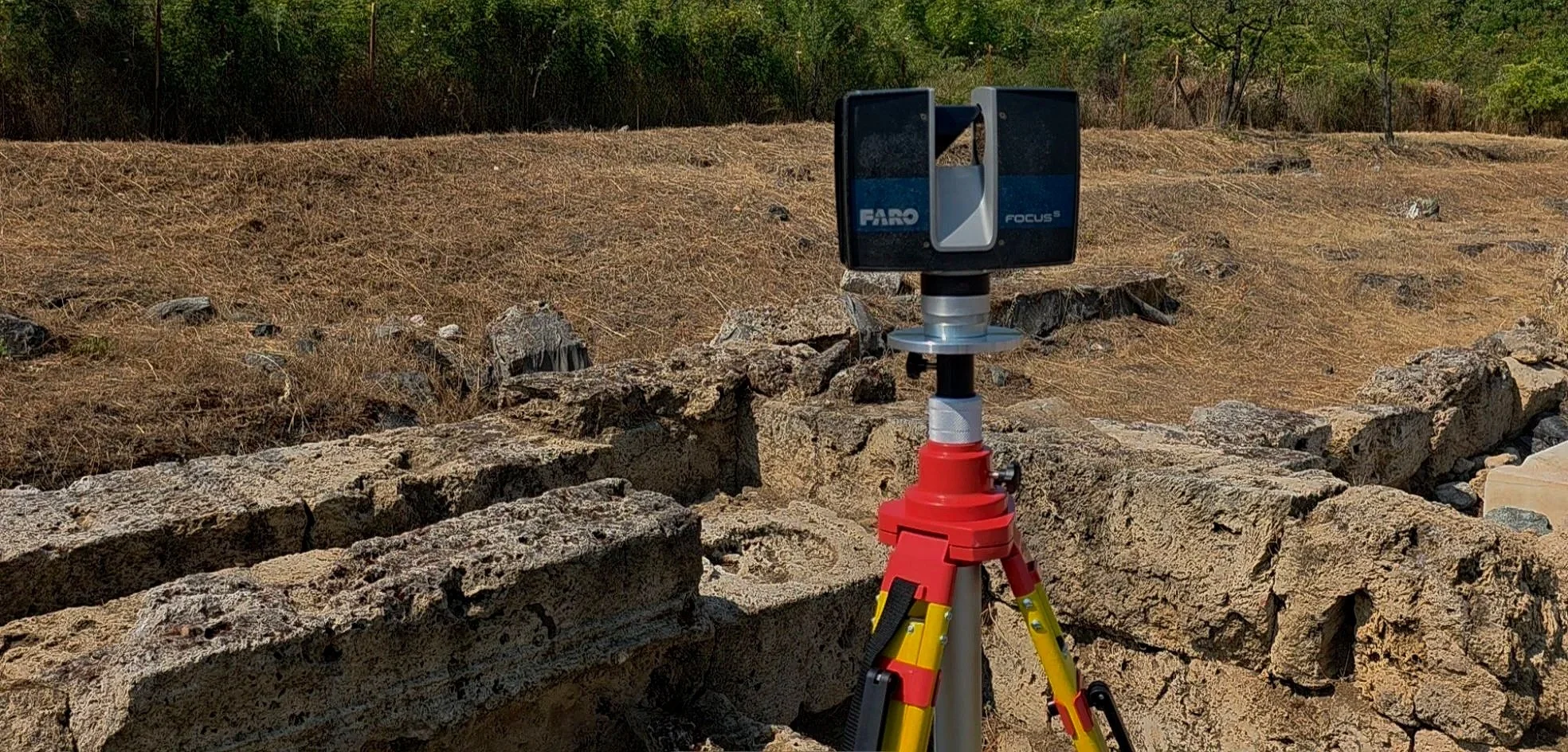
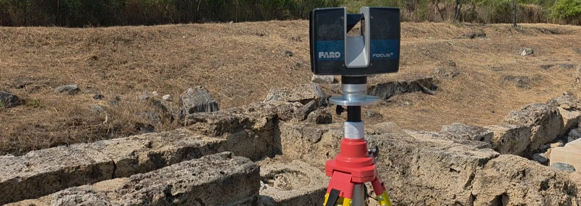
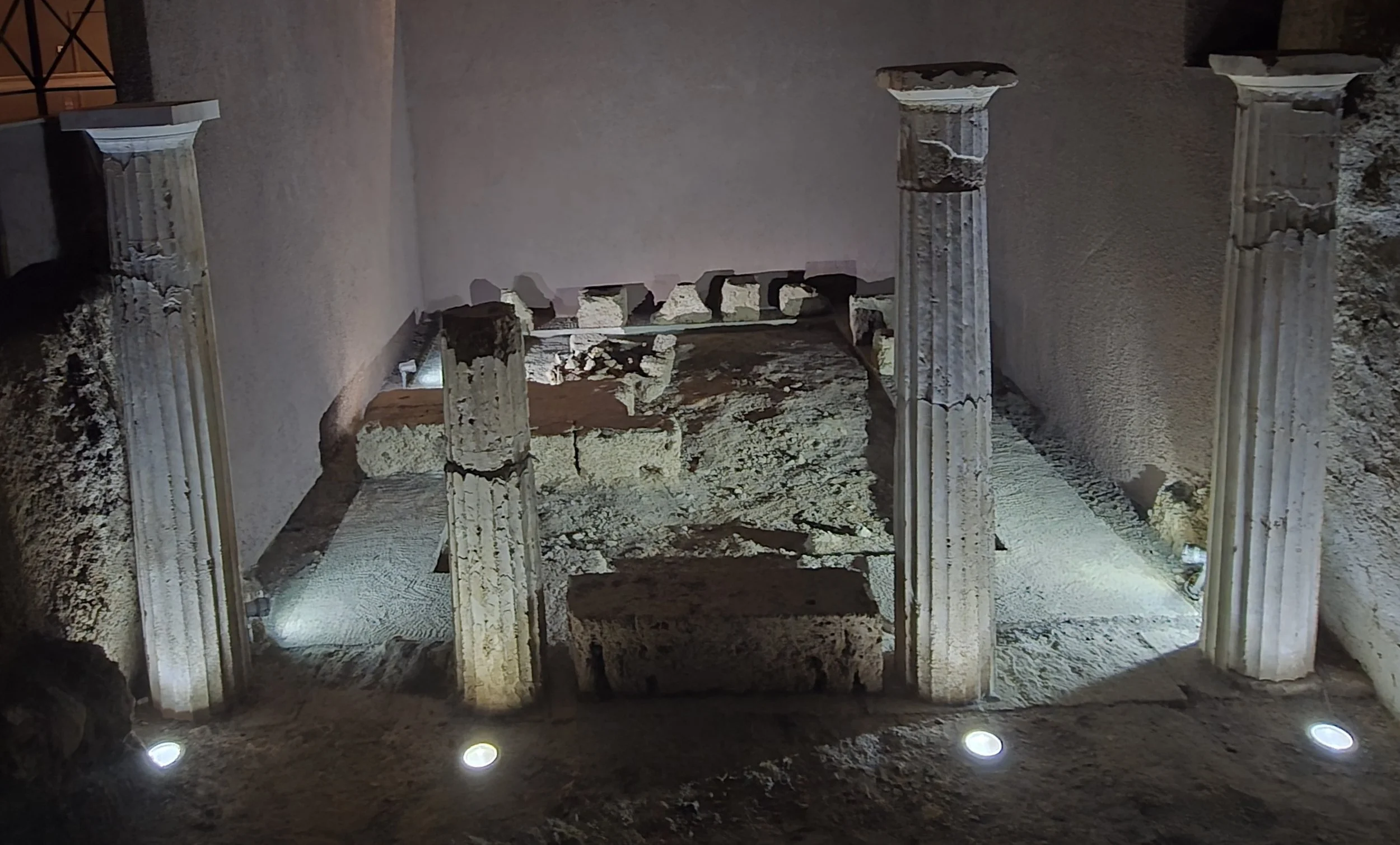
Using high-precision terrestrial laser scanning, the team digitally documented the Sanctuary of Eukleia, an important part of the ancient city and an active archaeological research site.
The project demonstrates how modern reality-capture technology can support archaeology by creating detailed, measurable 3D records of archaeological sites while allowing excavation and research to continue with minimal disruption.
Our role is to provide the technology and technical expertise that help archaeologists document what they uncover and preserve that information for future research.
Ilios will update this page when the data provided to the university is published.
3D Documentation at the UNESCO World Heritage Site of Aigai
The Ancient City of Aigai
The First Capital of the Macedonian Kingdom
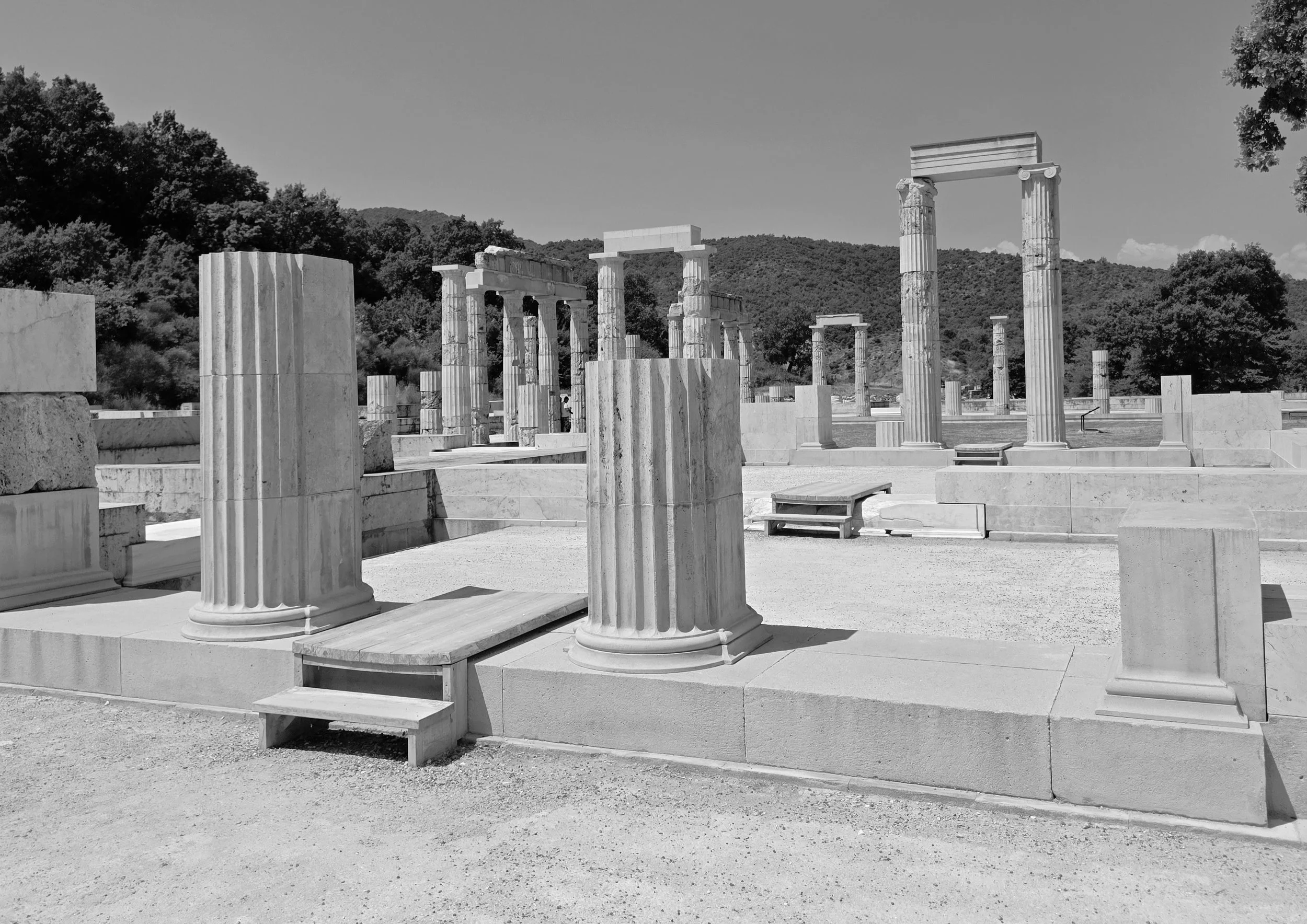
Aigai, located at modern Vergina in northern Greece, was the original capital and royal center of the ancient Macedonian kingdom.
The site includes the monumental palace, sanctuaries, extensive burial grounds, and the royal tombs, including the tomb identified as that of Philip II of Macedon, father of Alexander the Great.
The archaeological site of Aigai is recognized by UNESCO as a World Heritage Site for its exceptional importance to the history and development of the ancient Macedonian kingdom.
Today, archaeological research continues to reveal the urban, religious, political, and social landscape of one of the most important centers of the ancient Greek world.
A Long Tradition of Archaeological Research
Aristotle University of Thessaloniki at Aigai
Archaeological research at Aigai has a long association with Aristotle University of Thessaloniki.
Professor Konstantinos Rhomaios led important early excavations at the site before archaeological work was interrupted by the Second World War.
Professor Manolis Andronikos later resumed research at Vergina, and in 1977 his team made the extraordinary discovery of the unlooted royal tomb identified as that of Philip II of Macedon.
Archaeological exploration of the ancient city and its necropolis continued in subsequent decades under professors Stella Drougou and Chrysoula Paliadeli.
Research continues today, expanding our understanding of Aigai beyond its famous royal tombs and revealing the broader city in which the ancient Macedonians lived, worshipped, governed, and commemorated their dead.
The Sanctuary of Eukleia
Documenting an Important Part of the Ancient City
The Sanctuary of Eukleia provides important evidence for understanding the religious and civic landscape of Aigai.
Unlike the monumental royal tombs for which Vergina is best known internationally, investigation of the sanctuary contributes to a broader understanding of the functioning of the ancient city itself.
The ongoing excavation presents an ideal application for terrestrial laser scanning.
As archaeological excavation progresses, the physical condition of the site changes. Soil is removed, architectural elements are exposed, features are investigated, and new relationships become visible.
A detailed three-dimensional record provides researchers with another way to document those stages of discovery.
Archaeology necessarily changes the site being investigated. Digital documentation can preserve a record of what was visible at a particular moment in that process.
Terrestrial Laser Scanning for Archaeology
Capturing the Site in Three Dimensions
Traditional archaeological documentation remains essential. Terrestrial laser scanning complements those methods by rapidly capturing millions of spatial measurements across the visible surface of a site.
The resulting point cloud creates a measurable three-dimensional record of exposed architecture, terrain, archaeological features, and their spatial relationships.
Unlike a collection of individual measurements or photographs, the dataset preserves the geometry of the wider environment and can be revisited digitally after fieldwork has ended.
For archaeological research, this can support:
Detailed documentation of existing conditions
Measurement of archaeological and architectural features
Analysis of spatial relationships
Development of plans, sections, and other documentation
Comparison between different stages or seasons of excavation
Long-term digital preservation
Visualization and interpretation
Collaboration among researchers who may not be physically present at the site
Most importantly, laser scanning is a non-contact documentation method. Large areas and complex features can be captured without physically touching archaeological remains.
Creating a Repeatable Record
Documenting Change Over Time
One of the most valuable applications of 3D scanning in an active excavation is the ability to document the site repeatedly.
A single scan campaign records one moment.
Returning in subsequent excavation seasons can create a sequence of three-dimensional datasets documenting how the site changes as archaeological work progresses.
For the Aigai project, reference locations were established to support the repeatable positioning of survey targets during future scanning campaigns.
This provides the foundation for aligning future datasets with previous documentation and developing a long-term three-dimensional record of the excavation.
Rather than preserving only the final condition of the site, repeated documentation can help preserve the process of discovery itself.
Supporting Cultural Heritage
Preserving the Past With the Tools of the Present
Ilios Remote Sensing is committed to supporting museums, archaeologists, universities, nonprofit organizations, and cultural institutions where our technology and expertise can make a meaningful contribution.
Through our work with the Hellenic Archaeological Exploration Society and our academic and technical partners, we seek opportunities to apply terrestrial laser scanning, photogrammetry, virtual access, and other reality-capture technologies to archaeological and cultural-heritage projects.
Aigai represents an important example of that mission.
Ancient sites have survived for centuries or millennia. Digital documentation can help ensure that information about them survives for generations to come.
Technology in Support of Archaeology
The Technology Is a Tool. Archaeological Research Is the Purpose.
Reality capture does not replace excavation, archaeological interpretation, traditional survey, photography, drawing, or the expertise of archaeologists.
Its value lies in providing researchers with another form of evidence.
Terrestrial laser scanning can record enormous quantities of spatial information during a relatively short period in the field, preserving measurements and relationships that researchers may not realize are important until later.
A question that arises months or years after an excavation season may sometimes be investigated by returning to the digital record rather than relying solely on field notes and selected measurements.
That is one of the fundamental advantages of comprehensive reality capture:
Capture the physical environment now so researchers can continue asking questions of it later.
Collaboration
Technology, Archaeology, and Academic Research
The Aigai project brought together organizations with complementary roles.
Aristotle University of Thessaloniki conducts the archaeological excavation and research.
Ilios Remote Sensing and Norsk Remote Sensing contributed terrestrial laser scanning technology and reality-capture expertise.
The Hellenic Archaeological Exploration Society helped bring technology and archaeological research together as part of its broader mission to support archaeology, scientific research, and cultural heritage.
This collaborative model allows specialized technology and technical expertise to support the scholars responsible for investigating, interpreting, and preserving archaeological sites.
From the Pacific Northwest to Aigai
Ilios Remote Sensing applies the same fundamental reality-capture principles used to document buildings, vessels, machinery, and historic structures in the Pacific Northwest to cultural-heritage projects internationally.
The objectives, however, are different.
In commercial work, a point cloud may support design, fabrication, construction, or maintenance.
At an archaeological site, the priority is documentation, research, preservation, and the creation of a durable digital record for future study.
Our commercial work helps provide the technical experience and capabilities that we can bring to cultural-heritage projects such as Aigai.
Project Data & Research
Publication Will Follow the Archaeology
The terrestrial laser-scanning data collected at the Sanctuary of Eukleia was produced in support of the archaeological research conducted by Aristotle University of Thessaloniki.
Detailed project data, archaeological interpretations, and research results will not be published by Ilios Remote Sensing ahead of the responsible academic team.
This page will be updated as appropriate following publication and authorization of project materials by the university and archaeological team.
Interested in Cultural Heritage Documentation?
Museums, universities, archaeological projects, historic sites, and nonprofit organizations have very different documentation requirements.
If your organization is responsible for an archaeological site, historic structure, artifact collection, or other cultural resource and would like to explore how reality-capture technology could support its documentation, preservation, research, or public interpretation, we would be glad to discuss the project.